The Bali Pass Trek starts at Supin Valley and ends at Yamunotri Valley in Uttarkashi district, which are among the most beautiful river valleys in Garhwal Himalaya. Both valleys are separated by a ridge which trekkers rarely cross since the terrain is very difficult. Therefore, the Bali Pass Trek has an elevation of 4,950m (16,240 ft). This puts the trek in the list of serious high-altitude passes. Therefore, it is a trek for experienced trekkers who have done a few other Himalayan treks. For those seeking something challenging in Uttarakhand, this is one of the best options.
This route has a rich history even before trekking became common in Garhwal hills. Since time immemorial, Gujar shepherd tribes were migrating to other parts of Uttarakhand to graze their herds and flocks through Bali Pass. Today, the hiking trails of this region reflect the same spirit since they are well-traveled natural footpaths for the purpose rather than tourist destinations. The wooden architecture in Osla is rare to come across unless someone visits this place during trekking or mountaineering. Therefore, this route will take you through some unique architectural marvels.
The trek starts in Sankri village, which is the same starting point for Har Ki Dun and Kedarkantha treks. Once you get there, the route takes you through Taluka and then to the Supin river where you travel further to Osla Village, Debshu Bugyal (2 km-long alpine pasture) to Ruinsara Lake at 3,600m. The lake has a spectacular view of the peaks in the Bandarpoonch range. Further, the route passes through the Odari Cave site to Ruinsara Pass with its rocky terrain and snowy patches before descending on the other side to the Yamunotri Valley.
The total distance on the way is about 70 km in 8 days ending in Janki Chatti or Phoolchatti area. We organize the Bali Pass Trek in collaboration with experienced Garhwali guides who are aware of the annual changing conditions on this pass, an entire kitchen crew for all meals and accommodation en-route, and group transportation to/from Delhi. The permits for trekking in Govind Wildlife Sanctuary are taken care of before your journey starts. If you are seeking a challenge in Uttarakhand and want a trek that is far away from crowds - this one's for you!
The drive from Dehradun to Sankri is the long one - 220 km through the Garhwal Himalayas via Mussoorie, Nainbagh, and the Tons river valley, taking 9–10 hours. It is not the most comfortable drive, but the road passes through some genuinely beautiful stretches of the lower Garhwal, and the gradual rise in altitude means you arrive in Sankri already partway acclimatised to the mountain air.
Sankri sits at 1,950m in the Govind Wildlife Sanctuary, Uttarkashi district. It is a properly good base village - there are guesthouses and homestays, a small market, and the surrounding views of the Greater Himalaya include the Swargarohini group. Arrive by evening, check in, get a hot meal, review the following day's plan with your guide, and sleep early. The trek starts properly tomorrow.
TripToOcean departs from Dehradun at approximately 5:30-6:00 AM from a fixed pickup point. Confirm your pickup location at booking.
Overnight: Guesthouse in Sankri | Meals: Dinner
The day starts with a short drive from Sankri to Taluka, the motorable road end and actual trailhead for the Bali Pass route. From Taluka, the trail descends to the Supin River bed and then tracks upstream through dense bamboo and deodar forest, crossing a series of cement and wooden bridges over side streams.
The trail passes through Ghangad village, worth pausing at for its well-preserved traditional wooden architecture - carved pine beams and slate roofing that most visitors pass too quickly. Another hour brings you to the Supin's bank before the final push to Osla village.
Osla is the most interesting village on the entire route. The houses are almost entirely built from deodar wood in a traditional style - interlocking timber construction with decorated facades - that has survived remarkably intact. The village sits on a slope above the Supin, and trekkers have been stopping here long enough that the locals are used to it without being transformed by it. Camp is set up near the village.
Overnight: Tent camp near Osla Village | Meals: Breakfast + Lunch + Dinner | Trek: ~12 km, 5-6 hrs
From Osla, the trail continues up the Supin River and soon reaches Debshu Bugyal - a 2 km stretch of open alpine meadow that is one of the more visually striking sections of the early route. The meadow sits at around 2,800m and the views open up dramatically from here: Osla village visible below, the Swargarohini massif ahead, and the valley walls rising steeply on both sides.
Above Debshu Bugyal the trail steepens, drops to the river bed (loose stones, watch your footing), and then climbs again across a wooden bridge to reach the Seema camping area at around 3,110m. Seema is a popular stop for multiple trekking groups converging on the Ruinsara Valley approach, and the campsite has a good flat area for multiple tents. The Supin River is loud here and the surrounding peaks closer than at any point since Sankri.
Overnight: Tent camp at Seema / Chilurgad | Meals: Breakfast + Lunch + Dinner | Trek: ~10 km, 6-7 hrs
This is the day the trek reveals its best card before the pass itself. The 7 km from Seema to Ruinsara Lake is a steady climb through the upper Ruinsara valley - the trees thin, the meadows widen, and the scale of the Bandarpoonch range becomes clearer with every hour of walking.
Ruinsara Lake at 3,600m is one of the finest alpine lakes in the Uttarkashi range. It sits in an open bowl surrounded by meadows, with the Bandarpoonch (6,316m) and Kala Nag peaks dominating the skyline to the north. The lake is fed by glacial meltwater and on calm mornings the peaks reflect in it. There is a small temple structure near the lake associated with the Yamunotri pilgrimage tradition - this valley is on the old approach to the Yamunotri source.
Camp here tonight and the next night. The extra time at Ruinsara is intentional - it gives your body time to acclimatise at 3,600m before the approach to 4,950m on Day 6.
Overnight: Tent camp at Ruinsara Lake | Meals: Breakfast + Lunch + Dinner | Trek: ~7 km, 4-5 hrs
A shorter day by distance - 4 km - but the altitude gain matters more than the distance. The trail from Ruinsara to Odari climbs through increasingly sparse vegetation, crossing streams and passing above the last treeline before the rock and scree of the high terrain takes over.
Odari (13,100 ft) is a significant landmark on the Bali Pass route. It is named after the cave shelter here - "Odari" means cave in the local dialect - and tradition holds that this was a resting place of Bali (of Ramayana fame, hence the pass name). The cave is still usable as shelter in a pinch, though TripToOcean camps in tents nearby. From the Odari campsite, the Swargarohini peaks are in clear, close view - the finest sight of the entire approach.
In the post-lunch session your guide will run a brief technical briefing on the pass crossing - rope use, crampon or microspike protocols, pacing on scree and snow, and the sequence for the following morning's start. This is not optional.
Overnight: Tent camp at Odari | Meals: Breakfast + Lunch + Dinner | Trek: ~4 km, 3-4 hrs
The approach to the pass. Only 5 km, but the hardest section of the trek by difficulty. The trail from Odari to the Bali Col camp climbs steeply on a combination of snow, loose scree, and bare rock. There are sections at 60-degree incline. In May and early June, snow covers the approach and microspikes or rope assistance from the guide is standard. In October, it is more rock and scree than snow, but no less demanding.
The altitude gain from Odari (3,992m) to Bali Col (4,572m) in 5 km means you will be breathing hard regardless of your fitness level. Pace is everything here - your guide sets it and it will feel slow. Follow it. This is not a section to push.
Camp at the Bali Col in tents. Overnight temperatures here drop well below zero - sometimes to -10°C or lower in May. A sleeping bag rated to -15°C is the minimum requirement. The sky from this campsite, away from any light pollution with the peaks in three directions, is the kind of thing people mention years later.
Overnight: Tent camp at Bali Col (4,572m) | Meals: Breakfast + Lunch + Dinner | Trek: ~5 km, 5-6 hrs
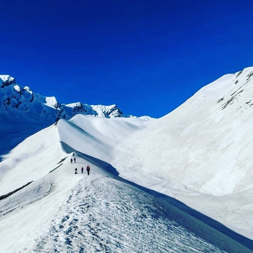
The pass day. Pre-dawn start - typically 3:30-4:00 AM with headlamps. The final push from the col to Bali Pass summit (16,240 ft) takes 2–3 hours on snow and mixed terrain. Your guide carries ropes for the steepest sections. The crossing itself is about 30 minutes at the summit ridge, with the view opening on both sides simultaneously - the Supin and Ruinsara valleys you came from to the south, and the Yamunotri drainage stretching north and east.
The summit of Bali Pass at 4,950m is the high point of the entire trek and one of the finest viewpoints in the Uttarkashi range. Swargarohini, Bandarpoonch, and Kala Nag are all within clear view. Take time here. This is the moment the 7 days of climbing were for.
The descent from the pass to Lower Dhamni on the Yamunotri side is long and steep - 750m of descent in about 7 km. The first section is on snow and demands careful footing. As you drop below the snowline into the Hanuman Ganga drainage, the landscape changes completely: streams, birch scrub, then lower forest. Reach Lower Dhamni camp by late afternoon, considerably warmer and lower than the morning.
Overnight: Tent camp at Lower Dhamni | Meals: Breakfast + Lunch + Dinner | Trek: ~12 km, 7-8 hrs
The final morning. The trail from Lower Dhamni descends through the Hanuman Ganga valley to the motorable road at Janki Chatti or Phoolchatti in the Yamunotri valley - about 3-4 hours of descending forest trail. This is the main pilgrim route to Yamunotri, so you will be walking alongside yatra foot traffic in May and September - a different atmosphere from the empty upper-valley terrain of the past week.
If the group has the time and inclination, the Yamunotri temple is 6 km further up the valley from Janki Chatti - worth the extra hours if your legs have anything left. The temple sits at the source of the Yamuna River at 3,293m. TripToOcean can arrange this as an optional extension if confirmed in advance.
At Janki Chatti, the group vehicle picks up the group for the return drive to Dehradun - approximately 5-6 hours via Barkot and Nainbagh. Arrive Dehradun by evening. Trek certificates are distributed at the vehicle before departure. End of services.
Meals: Breakfast
From Delhi: Delhi to Dehradun is approximately 250-300 km by road (5-6 hrs) or 5 hrs by Shatabdi Express. From Dehradun, TripToOcean's group vehicle departs at approximately 5:30 AM for Sankri (9-10 hrs). Total Delhi-to-Sankri time is approximately 16-18 hours. Recommended approach: take an overnight bus or early morning train from Delhi to Dehradun, then join the group vehicle at the Dehradun pickup point.
From Dehradun: Dehradun to Sankri is 220 km via Mussoorie, Nainbagh, and Mori - a 9-10 hour drive on mountain roads. TripToOcean arranges a group vehicle from a fixed Dehradun pickup point. The route passes Kempty Falls and the Tons valley - the scenery justifies staying awake.
Nearest Railway Station: Dehradun Railway Station (Shatabdi Express from New Delhi is the best option - book 2-3 weeks ahead).
Nearest Airport: Jolly Grant Airport, Dehradun (DED) -25 km from Dehradun. Flights from Delhi (45 min), Mumbai, Bangalore. Well-connected year-round.
Return Route: The trek ends in the Yamunotri valley (Janki Chatti), not Sankri. TripToOcean includes the return vehicle from Janki Chatti to Dehradun in the package - this is a separate vehicle arranged in advance and included in the cost. The Janki Chatti to Dehradun drive takes approximately 5-6 hours.
Important note for point-to-point logistics: Since you arrive by vehicle to Sankri and finish at Janki Chatti, you cannot return to pick up anything left in Sankri. Confirm all essential gear is with you on Day 1 before the trek departs.
Included in Your Package:
All meals - Day 1 dinner through Day 8 breakfast (breakfast + lunch + dinner throughout)
High-altitude tent camping for all 7 nights on trail
Government-licensed, experienced Garhwali trek guide
Cook + kitchen support crew on trail
Government-registered porter (1 per 2 trekkers, max 9 kg per trekker)
All porter, guide, and crew wages, meals, and equipment
Govind Wildlife Sanctuary entry permit
Uttarakhand Forest Department permits
High-altitude tents, sleeping mats, and kitchen tent
Group medical kit + emergency oxygen cylinder
Daily oxygen saturation checks from Day 4 onward
Ropes for technical sections of the pass crossing
Dehradun → Sankri group vehicle transfer (Day 1)
Janki Chatti → Dehradun group vehicle transfer (Day 8)
Trek completion certificate from TripToOcean
Not Included:
Travel to / from Dehradun
Personal sleeping bag - rated -15°C or colder (mandatory, not provided)
Personal trekking gear - boots, jacket, gloves, thermals, microspikes
Travel insurance covering emergency evacuation above 5,000m (mandatory)
Personal expenses - snacks beyond meals, hot drinks, laundry
Yamunotri temple visit (optional extension - contact TripToOcean)
Costs due to weather delays, trail changes, or force majeure
GST (5%) on package cost
The Bali Pass Trek is rated Moderate to Difficult and is not suitable for beginners. The pass crossing at 16,240 ft involves steep scree and snow at up to 60-degree incline, and the sustained altitude from Day 4 onward (above 11,000 ft for 4 consecutive days) demands both physical fitness and some prior acclimatisation experience. If you have completed a high-altitude trek above 12,000 ft before - Kedarkantha, Har Ki Dun, Brahmatal, or similar - you have the baseline preparation. If you have never trekked at altitude, do one of those routes first and come back to Bali Pass the following season.
Two windows: May-June (spring) and September-October (autumn). The spring window offers snow on the pass with the wildflowers in the valley; the autumn window gives drier trails and sharper mountain views with less snow on the approach. September and early October are often considered the best overall - the monsoon has cleared, the air is clean, the Ruinsara Lake reflects the peaks crisply, and the pass is accessible without deep snow. May is slightly more dramatic but physically harder due to snow cover on the approach. The trek does not run during monsoon (July-August) or winter (November-April).
Budget ₹25,000–₹30,000 per person all-in from Delhi for the shared group option.
reakdown: ₹18,999 TripToOcean package + ₹950 GST + ₹800-₹1,500 Delhi-Dehradun train (return) + ₹2,000-₹4,000 gear rental in Dehradun (sleeping bag, microspikes, poles) + ₹1,000-₹2,000 personal spending. Book Dehradun-Delhi trains 3-4 weeks ahead during the May-June and September-October peak seasons.
Ruinsara Lake is an alpine lake at 3,600m in the Ruinsara valley of Uttarkashi district, surrounded by open meadows and backed by the Bandarpoonch range. It is fed by glacial meltwater and sits in a natural bowl that gives unobstructed views of Bandarpoonch (6,316m) and Kala Nag (6,387m) - two of the most striking peaks in the Uttarkashi range. On calm mornings the peaks reflect clearly in the lake surface. There is a small religious structure at the lakeside associated with the Yamunotri pilgrimage tradition. The Bali Pass Trek route camps here for the acclimatisation night, which gives trekkers a full evening and morning at the lake - enough time to actually sit with it rather than just walk past.
The trek finishes at Janki Chatti or Phoolchatti in the Yamunotri valley, which is the starting point for the pilgrim walk to Yamunotri temple. The temple itself is 6 km further up the valley from Janki Chatti at 3,293m - a 3-4 hour round trip on foot or by pony. Trekkers who want to include the temple visit after completing the pass trek can do so with advance planning. TripToOcean can arrange an extended Day 8 to include the Yamunotri temple visit before the return vehicle to Dehradun - contact us at booking to add this. The vehicle timing from Janki Chatti can be adjusted accordingly.
Osla is a traditional Garhwali village on the Supin River in the Govind Wildlife Sanctuary. It is notable for its wooden architecture - houses built almost entirely from deodar timber in a traditional interlocking construction style that has survived largely intact because the village is remote enough that it was never redeveloped. The carved wooden facades and multi-story construction are genuinely worth the time to look at. The Bali Pass trekking route passes directly through Osla on Day 2, and TripToOcean schedules a rest stop here. The village sees trekking groups regularly and a few households serve chai and basic snacks to passing trekkers.
The Bali Pass Trek route from Sankri through the Supin valley, Osla, Ruinsara, and Odari passes through Govind Pashu Vihar National Park and Wildlife Sanctuary - a protected forest area in Uttarkashi district that is home to snow leopard, Himalayan black bear, serow, and musk deer among other wildlife. Entry into the sanctuary requires a permit from the Uttarakhand Forest Department. TripToOcean arranges this permit as part of the package cost - you do not need to apply separately. A valid government ID in hard copy is required for permit processing.
Both treks use Sankri as their base and both go through the Supin river system, but they are significantly different experiences. Har Ki Dun is 6-7 days, reaches 11,680 ft, and is a valley trek with no high pass - suitable for people with limited trekking experience who want a beautiful, relatively easy Himalayan route. Bali Pass is 8 days, reaches 16,240 ft, crosses a genuine high pass, and requires prior altitude experience. The scenery on Bali Pass is more dramatic - Ruinsara Lake and the Swargarohini views from the pass have no equivalent on the Har Ki Dun route. If you have done Har Ki Dun and want the next level from the same region, Bali Pass is the natural progression.
Both treks use Sankri as their base and both go through the Supin river system, but they are significantly different experiences. Har Ki Dun is 6-7 days, reaches 11,680 ft, and is a valley trek with no high pass - suitable for people with limited trekking experience who want a beautiful, relatively easy Himalayan route. Bali Pass is 8 days, reaches 16,240 ft, crosses a genuine high pass, and requires prior altitude experience. The scenery on Bali Pass is more dramatic - Ruinsara Lake and the Swargarohini views from the pass have no equivalent on the Har Ki Dun route. If you have done Har Ki Dun and want the next level from the same region, Bali Pass is the natural progression.